From underwriting to claims, aerial data can speed property workflows.
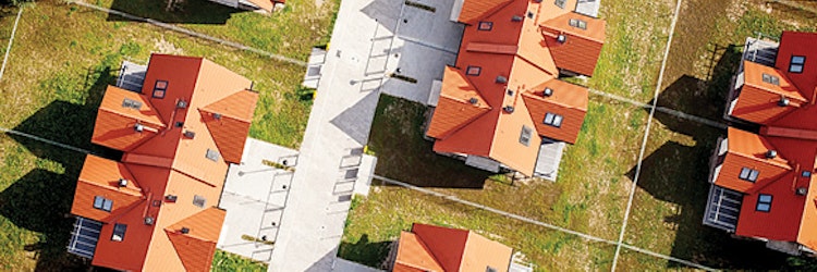
A bird’s-eye view can offer valuable insights. That’s why the property insurers has used aerial imagery for underwriting and catastrophe analysis for decades. Aerial images help carriers underwrite properties remotely, set better reserves, and allocate resources more quickly after a disaster. Severe weather is responsible for a sizable majority of homeowners’ claims, and can be time consuming and complex for insurers to handle. As a result, streamlining workflows has become a top priority for many, which is why advances in aerial data are playing a crucial role in the property industry.
We know that hail, wind, and severe weather remain a significant challenge for insurers and account for a large proportion of homeowners’ claims. To cope with mounting pressures of handling these claims, many insurers are searching for ways to shorten workflows and trim operating costs. In recent years, aerial data typically has become a linchpin in helping improve underwriting decisions, streamline loss inspections, combat fraud, and respond to catastrophes more efficiently.
For much of its history, aerial imagery has been captured with mapmakers and surveyors in mind, and it has worked well when dealing with huge parcels of land. But when repurposed for insurers that deal with individual structures, the amount of data that imagery provides often was limited. For insurers, the more detailed an image, the greater the data that can be mined from it.
As demand has risen for aerial data tailored specifically for the insurance industry, specialists in geospatial technology and data have harnessed advances in camera technology and analytical algorithms to devise new ways to capture and analyze structures. Due in large part to those efforts, insurers now have greater access to massive amounts of data that can be used to help expedite many workflows.
Automating Inspections
Insurers have made great strides in automating many steps in underwriting, but there is one area where more can be done: inspections. Gathering information about structures and identifying factors that affect underwriting decisions can be critical. But property inspections tend to be expensive, costing the industry more than $150 million each year, according to estimates from Verisk Insurance Solutions. Through use of aerial data, underwriters can evaluate properties more rapidly while maintaining the quality of underwriting decisions.
With this highly detailed information, underwriters can learn much of what they need to know about structures without leaving their desks. Exterior dimensions and data can be used to calculate square footage of livable space, number of stories, roof shape and size, and other characteristics necessary to determine replacement value. Underwriters also can gauge the age and quality of exterior walls and roof materials, taking much of the guesswork out of determining the condition of the structure.
High-resolution aerial imagery also can give a clearer view of potential risks, including pools, trampolines, and fire lines. All of this documentation often can be gathered without deploying an inspector to the site, which better ensures frontend underwriting matches backend handling of claims.
At the Loss Site
After a loss, estimators typically spend much of their time measuring structures and analyzing building materials before they can begin estimating repairs, which often can extend cycle times. An Xactware analysis reveals that in 2015, it took an average of two days for estimators to inspect a typical wind or hail loss and return an estimate report. The same analysis shows that the larger the loss, the longer the cycle time. For hail and wind losses between $25,000 and $50,000, estimators returned their reports after four or five days. If damage or key measurements are missed, follow-up visits often need to be arranged, which can further delay settlement and reduce customer satisfaction.
Obtaining comprehensive aerial data immediately after the first notice of loss can expedite loss site inspections and facilitate on-site settlements. Before arriving at the site, estimators can download a three-dimensional rendering of the exterior structure with much of the information needed to assess the loss, including the number and placement of doors, windows, flatwork, outbuildings, decks, and more.
Detailed information on roof and exterior building materials helps speed up the analysis, enabling the estimator to spend less time measuring and scoping and more time documenting the loss, calculating repair costs, and addressing homeowners’ concerns. In many instances, the property data can be downloaded to the estimator’s mobile device, facilitating settlement on the first visit. Aerial data also serves the dual purpose of reducing on-site accidents.
Insurance professionals are keenly aware of the perils associated with working on compromised building structures and constantly are seeking new methods to document roof losses accurately while ensuring the safety of estimators. With aerial data that includes roof measurements, slopes, and material analysis, estimators need only capture a few images to document damage. This typically can be done from the safety of a ladder, significantly reducing the time spent on dangerous roofs and greatly improving the safety of roof loss adjusting.
The Billion-Dollar Drain
Fraud is a critical issue for insurers and policyholders alike. The Insurance Information Institute estimates that fraudulent property/casualty claims amounted to $32 billion annually between 2009 and 2013. The Federal Bureau of Investigation also reports that fraud costs the average American family between $400 and $700 per year in increased insurance premiums.
Fraud schemes are becoming increasingly difficult to detect, placing greater pressure on insurers to implement more efficient ways to sift out deceitful claims from meritorious ones. Aerial data that includes high-resolution imagery often can serve as indisputable documentation that shows the condition of properties before a loss. Detailed analysis of building materials that includes the age and condition of exterior finishes and shingles also can help settle disagreements about repair estimates.
In the aftermath of a major disaster, insurers can be stretched to their limits as they rush to address the needs of thousands—sometimes tens of thousands—of policyholders. In these extreme situations, estimators’ workloads can double or triple overnight. Access to entire neighborhoods can be restricted due to safety concerns, drawing out cycle times and leaving homeowners in limbo as they wait for their claims to be addressed.
With aerial data, estimators can jumpstart the claims process before an on-site visit takes place. Digital renderings provide dimensions and slopes; high-resolution images give a clear view of the property before the loss; and detailed material analyses help compile preliminary repair estimates that can be modified quickly once the estimator is allowed to inspect the site. Policyholders often are impressed by the rapid response and cutting-edge approach to handling claims, and emerging technologies will only enhance the process in coming years.
Age of Drones
Over the past few years, unmanned aircraft systems (UAS), more commonly referred to as “drones,” have become a hot topic in the insurance industry because of their enormous potential for increasing efficiency. The high-definition cameras that come with drones take aerial data to the next level, facilitating the capture of vital details that enhance the speed and precision of many property workflows, including underwriting and claims handling, while improving loss site safety and customer service. Many nationwide insurers recognize the benefit of using such technology and have received the Federal Aviation Administration’s (FAA) approval to test and deploy UAS. It’s no longer a question of if drones will play a role in the property industry; it’s a question of how.
UAS will continue to become more prevalent as the FAA navigates the thorny issue of safely integrating them into U.S. airspace. Estimators already have access to comprehensive aerial data and complete exterior diagrams of structures, but drones may become a common tool of the trade to inspect potential damages while keeping both feet safely on the ground. After a natural catastrophe, deploying a drone would be an efficient way to survey entire neighborhoods rapidly.
As UAS and other remote sensing technologies become more prevalent, insurers will need to establish stringent guidelines to help promote responsible deployment of the technology. Industry leaders, geospatial experts, and computer scientists are forming collaborative groups to study how this emerging technology can be deployed most effectively while ensuring safety. Ultimately, such advances in technology likely will lead to greater efficiency and precision in claims handling.
Claims stemming from severe weather continue to present considerable challenges, but insurance carriers are proving their resilience by adopting emerging technologies to streamline their workflows. Through the use of aerial data, insurers are helping improve underwriting, claims handling, and catastrophe response while promoting greater safety measures and more sophisticated fraud detection. Ongoing advances in aerial data capture and analysis likely will lead to greater efficiencies in property workflows.
Clyde & Co. professionals discuss this year's key trends

