November 15, 2017
Earlier this year, EagleView was granted a patent from the U.S. Patent and Trademark Office that allows a drone to follow an automated flight path based on a commercial or residential property. The kicker? A pilot isn’t needed to calculate the flight path. EagleView President Rishi Daga explains how it works.
You say the flight plan doesn’t require a pilot. Can you explain what that means? Is there still an operator nearby?
Absolutely, there is a pilot involved and, in fact, the current regulations for flying commercial drones require that there be a licensed pilot on-site and that the drone remains in the sight of the pilot at all times. The patent says that the pilot does not need to calculate the flight path, just monitor the drone while it’s in flight. The pilot can override the flight path at any given time if he feels something could become a problem, such as a bird. We work with an extensive network of drone operators throughout the country.
Walk us through the process step by step and what the report looks like when it lands on a claims professional’s desk.
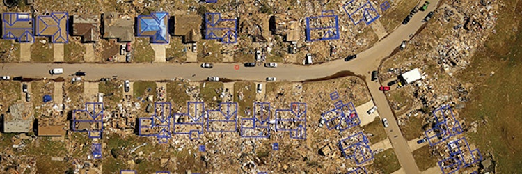
The report blends drone captured imagery and (through machine learning) indicators of where potential damage exists for claims professionals to consider in their inspections. This report is merged in an application with “pre-event imagery”—imagery of the property before the event that resulted in the claim—as well as weather information and building measurement information. The claims professional has a single record file with pre-event and post-event imagery, a report, and claim information.
Are there any concerns that the drones/operators are acting as claims professionals in the states that require licensing in order to handle claims?
It may be the case that a licensed claims professional is also the drone operator, but in most cases the drone operator is not a claims professional and is strictly instructed to avoid any conversation about damage or coverage and only capture and upload the imagery needed to create the report. That is why this patent is so important; it ensures that the drone operator is capturing exactly what the claims professional needs in a consistent and reliable way.
How did Hurricanes Harvey/Irma/Maria test the process? Was there anything these disasters taught you when it comes to drone usage?
Those three hurricane events were very different. Drones were deployed less frequently in Hurricane Harvey than in Hurricane Irma because Harvey was predominantly about flooding while Irma had a wide area of homes with wind damage, which is the sweet-spot for drone inspections. You don’t need a drone to know that a house is flooded or completely destroyed. Following Irma, we performed thousands of drone inspections in the areas where there was wind damage to home exteriors.